Aug 23, 2008
The Border Fence Project
The Border Fence Project is sponsored by NoInvaders.Org, a non-profit organization founded by Jim Wood of Running Springs, CA, on December 13, 2004, one of the original Minutemen and weekly visitor to the Mexican border, as well as a 3-year active veteran of the immigration reform movement in excellent standing with the state of California. We are 501 (c) (3) tax exempt as part of Declaration Alliance. We pride ourselves in offering fencing solutions free to private ranchers along the southern border with Mexico, along with free public property fencing along the International Zone, in an effort to help stop the ever escalating tide of illegal immigration, terrorism, and drug smuggling. We are in the process of considering a border fence project for the Canadian border as well. Your support of this organization, as well as promotion of and contribution to, will be in recognition by a 200,000+ membership of Minutemen-like groups from around the nation, and the 80% of the American public who want greater restrictions on illegal immigration.
Aug 19, 2008
NOW: The Border Fence
PBS NOW senior correspondent Maria Hinojosa travels to Texas to meet border families who fear losing their property, their safety, and their way of life. We also follow an investigative reporter who questions whether certain landowners are getting preferential treatment. Website includes documentation of Walls of the World.
Aug 13, 2008
Three Million Dollar Mile
When the House of Representatives first approved a border security bill, it was estimated that it would cost $2.2 billion. A Congressional Budget Office echoed that figure in May with an estimate of $3 million per mile -- $2.1 billion for 700 miles.
The cost of building and maintaining a double set of steel fences along 700 miles of the U.S.-Mexico border could be five to 25 times greater than congressional leaders forecast last year, or as much as $49 billion over the expected 25-year life span of the fence, according to the nonpartisan Congressional Research Service. The little-noticed study the research service notes that even the $49 billion does not include the expense of acquiring private land along hundreds of miles of border or the cost of labor if the job is done by private contractors -- both of which could drive the price billions of dollars higher.
The cost of building and maintaining a double set of steel fences along 700 miles of the U.S.-Mexico border could be five to 25 times greater than congressional leaders forecast last year, or as much as $49 billion over the expected 25-year life span of the fence, according to the nonpartisan Congressional Research Service. The little-noticed study the research service notes that even the $49 billion does not include the expense of acquiring private land along hundreds of miles of border or the cost of labor if the job is done by private contractors -- both of which could drive the price billions of dollars higher.
Aug 12, 2008
Virtual Wall

A 28-mile virtual fence is rising along the border. It comes in the form of nine nearly 100-foot-tall towers with radar, high-definition cameras and other equipment. Known as Project 28, for the 28 miles of border that the towers will scan, the so-called virtual fence forms the backbone of the Secure Border Initiative, known as SBInet, a multibillion-dollar mix of technology, manpower and fencing intended to control illegal border crossings. However, the viability of a high-tech barrier to detect illegal border crossers remains uncertain, after a pilot project struggles.
Aug 8, 2008
The Wall: The Films

The Wall is a documentary about the Secure Fence Act of 2006.


The Border Wall is a new documentary from filmmaker Wayne Ewing about the attempt by the Department of Homeland Security under Secretary Michael Chertoff to erect 670 miles of walls along the 2000 mile southern border of the United States in the waning days of the Bush administration. The Border Wall Documentary Website
Border Fence Environmental Planning
On April 1, 2008, the Secretary of the Department of Homeland Security (DHS), pursuant to his authority under Section 102(c) of IIRIRA, exercised his authority to waive over 30 environmental and other laws and regulations associated with construction of tactical infrastructure along the southwestern border. Although the Secretary’s waiver means that CBP no longer has any specific legal obligations under these laws, the Secretary committed the Department to continue to protect valuable natural and cultural resources. CBP strongly supports this and remains committed to being a good steward of the environment. [ Border Fence Environmental Planning ]

Border Fence Proposal Maps in the Rio Grande Valley

The U.S. Border Patrol is proposing to install fences, patrol roads, lights and other infrastructure along about 70 miles of the U.S.-Mexico border in the Rio Grande Valley. [ View a map of the Rio Grande Valley Fence Proposal | General Locations of Tactical Infrastructure in Lower Rio Grande Valley | Locations of the Proposed Tactical Infrastructure - Mid Rio Grand Valley | Locations of the Proposed Tactical Infrastructure - Upper Rio Grande Valley | General Location of the Proposed Action - Rio Grande Valley Sector, Texas ]
Inflatable Border
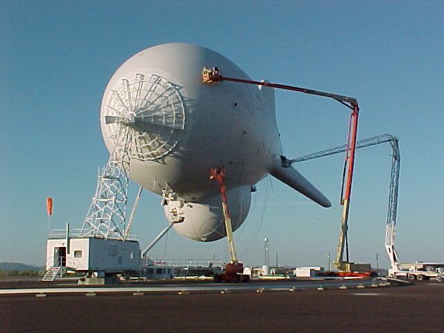
The Tethered Aerostat Radar System is a low-level surveillance system that uses aerostats as radar platforms. An aerostat is a lighter-than-air, inflatable, aerodynamic balloon filled with helium and air. The primary mission is to provide low-level radar surveillance along the southwest border of the United States and Mexico, the Straits of Florida and the Caribbean in support of federal agencies involved in the nation's drug interdiction program.
The following payloads have been successfully deployed on TCOM aerostats:
- Surveillance radars of all sizes and capabilities
- Signal Intelligence (SIGINT) collection equipment
- Gyro-stabilized daylight, low-light level and infra-red video cameras
- Direct television broadcast and relay
- FM radio broadcast and relay
- VHF/UHF, Ground Control Intercept (GCI) and microwave communications
- Environmental monitoring equipment
Our Wall

Aug 6, 2008
Borderless Landscape

Subscribe to:
Posts (Atom)